KANSAS CITY — Weather gurus around the world soon will be turning their attention to the approaching Northern Hemisphere growing season, and do you know what they will find? They will discover two areas of significant dryness: one in western North America and the other in western Asia. Because of a fear that the conditions will persist, these two broad areas of dryness will attract great interest as the growing season commences.
Late autumn, winter and early spring are the most important seasons for healing dryness. Droughts can break down during the warm season, but it is more difficult because of warm temperatures and higher evaporation rates. The optimal time for recovery from dryness is the cool season.
The 2020-21 cool season is a little more than half over, and looking around in the Northern Hemisphere there has not been much progress whittling away at the two most widespread droughts. The toughest part of examining drought this time of year is getting through the topsoil, which is usually more favorably charged with moisture than the subsoil and can hide long-term dryness.
One area that has been struggling with dryness during much of the past decade is eastern Ukraine, Russia’s Southern Region and immediate neighboring areas. One of the most serious droughts in modern history has affected some of these areas over the past 5 to 15 years. Portions of the Lower Volga River Basin have been in drought more than three-fourths of the period from 2005 to today, but that is the exception and not the rule. These drought statistics come from the “SPEI Drought Monitor,” which is a hybrid of the Long Term Palmer Drought Severity Index and the Standardized Precipitation Index.
Most of the drought in western Asia occurred in notable waves, one in the early 2010s and the other the most recent three years. The data seem to be a little skewed, but the trend is not far off from reality, and the recent La Niña event has capitalized on the drought region further extending dryness for another growing season.
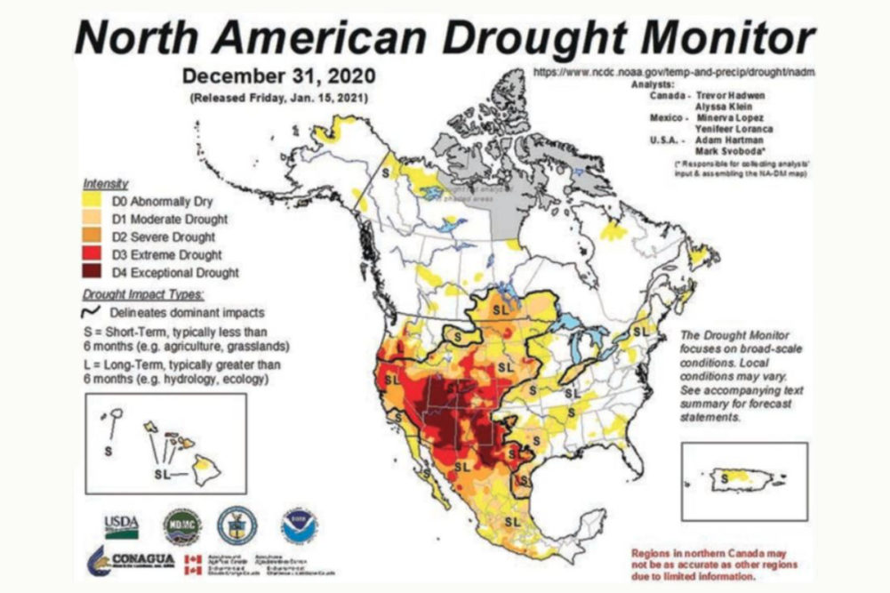
La Niña should weaken over the next few months, and that should lead to improving “opportunities” for drought relief, not only in western Russia, but in North America as well. Dryness in western Asia extends north from Turkey and a small part of the eastern Mediterranean Countries into Russia’s Southern Region, eastern Ukraine and a part of Kazakhstan. In North America drought extends from Mexico through all of the western United States (except the Pacific Northwest) to eastern portions of Canada’s Prairies.
The North American drought is most serious in the west-central and southwestern Plains through the central and southern Rocky Mountain region to California, and it extends southward into northern Mexico.
The drought in western North America is expected to diminish considerably during the late winter and spring this year, but it may not completely go away, leading to much speculation about summer weather in North America, especially when it is combined with lingering La Niña conditions and a developing negative Pacific Decadal Oscillation (PDO).
It is never good to come into spring with dryness already a problem in the soil. This truism applies both to the western United States as well as the heart of the Plains and Midwest. The broad-based region of dryness from Mexico to Canada’s eastern Prairies must be eliminated in the next few months to reduce the potential for strong ridge building in the central parts of North America. Cooling ocean water off the West Coast of North America (a phenomenon often associated with the negative phase of PDO) in recent months has not yet become significant enough to throw the summer weather pattern into a more threatening environment. However, the drought already prevailing in western North America could help expand the influence of the developing negative phase of PDO so that a ridge of high pressure develops faster than usual this spring, and with greater amplitude (intensity). Such an occurrence could lead to expanding dryness in the US Plains and western Corn Belt.
The influence of negative PDO and ongoing drought in western North America could be further influenced by lingering La Niña conditions. Some computer forecast models for ENSO (La Niña and El Niño) events have suggested weak La Niña conditions may be present during the spring and summer.
World Weather, Inc. is not convinced the forecast is right, but the suggestion of lingering La Niña leaves some level of concern over less-than-usual rainfall in a part of the US Plains and western Midwest as well as western Asia — if these conditions prevail through spring.
Other indications suggest that for a while this spring, the central United States will get involved with an improving precipitation pattern. That would help to break down some of the dryness in the Great Plains and add to moisture in the soil across the western Corn Belt. However, these improvements will be a little superficial and may be only temporary.
If the negative PDO trend remains through spring and into summer while long-term dryness remains, (despite some improved spring precipitation) and La Niña lingers, the impact will not bode well for summer precipitation potentials. In addition to these factors there is already weak ridge building advertised in the central parts of North America starting in May and continuing into the summer. The ridge actually may first appear over the Midwest in early spring, and it will then retrograde (shift westward) during late spring and summer.
The bottom line to all of this discussion is pushing the central parts of the United States more toward a summer moisture shortage after a period of relief from dryness this spring. How serious the dryness will be remains to be seen and largely will be dictated by how much rain falls this spring, any further development in PDO and whether or not La Niña actually does prevail. Moisture shortages do not necessarily translate into crop hindering drought, but some stressful conditions might evolve in at least some areas.
World Weather, Inc. also is concerned these conditions could be setting the stage for a more extended period of less-than-usual rainfall in key US crop areas that could extend into 2022 and possibly 2023. Even though much of this discussion is still considered highly speculative, there is little reason to believe that a return to the very wet years of 2016-18 will occur any time soon. A much wetter shift is unlikely because of the coincidence of all these weather influences with the recent passing of the solar minimum.
The next few years should favor La Niña and less-than-usual precipitation for parts of North America and western Asia, and persistent La Niña will help to reinforce negative PDO. All of these factors suggest multiple years of moisture shortages are possible similar to those of the 1980s, 1950s, 1930s and late 1800s. How severe dryness becomes will be dependent on factors that cannot be discussed in this space, but this would be a great time for food companies to align themselves with a defensive purchasing plan.


